Navigation - Finding Your Way

|
In a survival situation, or when GPS is unavailable, finding the path to a specific destination, or to avoid getting lost, does require some special skills and knowledge. Hopefully, these links and information will help prepare for whatever situation arises, whether the car/cell battery is dead, technology is unavailable and the way to get back to civilization is unknown.
Several of the following links provide thorough yet simple instruction on how to navigate with just a compass and map |
What to Do When You're Lost in the Wilderness: When you are lost, the trick isn't to find your destination. The trick is to find out exactly where you are starting from; you must, first, know where you are. Most people think that navigation is about finding your way to some destination. Clarity of your end goal is most certainly important, but it is also meaningless if you don’t know where you are starting. Think about a GPS or map app — if you put in the destination but the app cannot find where you are, there is no way of mapping the right directions.
- 1. Don't panic and stay calm - Panic or stress is instinctive when lost. It’s important to sit down and collect your thoughts. In the wilderness, this includes assessing how much water or food you have, and perhaps even setting up some shelter. Depending on how lost you are, the first step is to set up camp. Consider the 3 Zones of Assessment, S.T.O.P. to get your bearings and focus on S.U.R.V.I.V.A.L..
- 2. Retrace your steps - Think back to a time and place you confidently knew where you were. Going back to that point may help you join the path to your original destination. If you start down the path of retracing your steps and find yourself feeling more lost, then it is best to abandon this step. Move on to finding higher ground.
- 3. Find higher ground - Moving to a summit or a ridgeline provides perspective and broadens one's horizons. From a higher vantage point, we may be able to see more options.
- 4. Triangulate your position - Triangulation is a technique hikers use to figure out where they are. From a higher vantage point, you can use three known points of reference in your field of vision. It might be three different mountain summits in the horizon. Using a compass and map, you can figure out where you are.
- 5. Consider your options and make a plan - In many cases there are multiple options or directions one can take:
Rejoining the path to your original destination
Forging a new path to a new destination
Finding an exit plan to get to further safety and assistance
- 6. Take action - If you are confident that moving will find your way out, get moving. Sometimes the action may be to stay put for assistance.
Sewing Needle & Leaf Compass:
Supplies:
Small bowl
Water
Small leaf
Thin metal wire (sewing needle, paperclip, twist-tie, hair/bobby pin, small piece of coat hanger, etc.)
Directions:
Step 1: Pour water into a small bowl. The water should be still without ripples or movement.
Step 2: Carefully place the leaf onto the surface of the water, making sure it does not sink or get wet.
Step 3: Stroke the needle against another piece of metal or wool clothing or fabric 50-100 times in the same direction. This magnetizes the needle.
Step 3: Gently place the needle on top of the floating leaf. The needle will align with the Earth’s natural magnetic field.
Video 1 Video 2
What is a .GPX File? A GPX file is a GPS data (navigation) file that can be used without a GPS. It is saved in the GPS Exchange format, which is an open standard used by many GPS programs. It contains longitude and latitude location data that may include waypoints, routes, and tracks. GPX files are saved in XML format, which allows GPS data to be more easily imported and read by multiple programs and web services. No GPS device is needed to read a GPX file so Personal Emergency Locations can be stored in the GPX file and saved on a USB drive or smart phone and opened with a GPX Viewer App or GPX software on a computer/tablet. Read more here to learn how to create, open, use and save a GPX file.
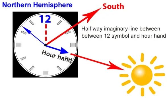
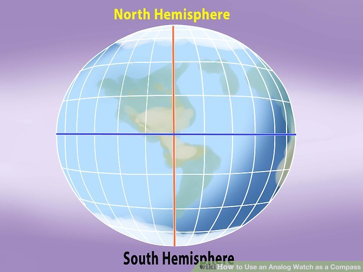
Using a Watch to Find North: The watch method for navigation is useful for finding the cardinal directions of: north, south, east and west. While not being 100 percent accurate, it is handy for crude navigation when a compass is not available and can head you in the correct general direction in camping, bushcraft, backpacking and survival situations. It is also useful in combination with other natural navigation methods found in this document and other resources.


Northern Hemisphere:
Align a twig (pointing up) at the edge of your watch so that it casts a shadow onto the face of the watch from the Sun.
Rotate the watch until the twig's shadow (the Sun) is cast directly onto the hour hand.
The halfway point between the hour hand and the 12-oclock mark is your North-South line. Note that during Daylight Saving Time (or Summer Time), your watch is most likely one hour "off" from the "real" time. If this is the case, substitute 1 o'clock for 12 o'clock before finding your North-South line.
The halfway imaginary line will point to South
If only a digital clock is available, draw an analog/dial clock (with the correct time) on paper or in the dirt.
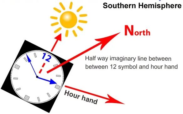
Southern Hemisphere:
Align a twig (pointing up) at the edge of your watch so that it casts a shadow onto the face of the watch from the Sun.
Rotate the watch until the twig's shadow (the Sun) is cast directly onto the 12-oclock mark.
The halfway point between 12-oclock and the hour hand is your North-South line. Note that during Daylight Saving Time (or Summer Time), your watch is most likely one hour "off" from the "real" time. If this is the case, substitute 1 o'clock for 12 o'clock before finding your North-South line.
The halfway imaginary line will point to North.
If only a digital clock is available, draw an analog/dial clock (with the correct time) on paper or in the dirt.
Trail Blazing:
No matter what form trail markings take, their ultimate goal is to communicate where a hiker is currently, and where they need to go next. In a survival situation, marking trees is essential to communicating direction of travel to rescuers and help the hiker stay on course. Basic markings are one (| = Away from Camp) or two (|| = Back to Camp) verticle lines. These lines appear on opposite sides of a tree, cut into the bark with a knife or hatchet. If you've built a campsite, look for two verticle lines to find your way back to camp. If you are blazing a way out, seeing two lines means you're going in circles. Other methods of marking can be used (charcoal, ribbon, chalk, rocks, logs) to prevent tree damage but make sure they are visibly obvious, aren't easily destroyed and can be clearly visible from the last marker.
References:
Basic How to Use a Compass and Map (video)
Basic How to Use a Compass and Map (slides)
Getting Unlost in the Desert
Find True North Without a Compass
How To Navigate In The Wild Without A Compass
How To Get Un-lost
Survival Navigation
Suggested Readings:
Preparing Your Vehicle for an Emergency
Bug Out or Stay Put?